

Pointly Custom Classifier – Tailored AI for 3D Point Cloud Data
Turn Your 3D Point Clouds into Actionable Data
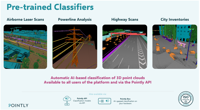
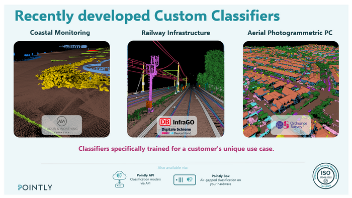
Pointly’s Custom Classifier enables organizations to automate the analysis of 3D point cloud data with AI models specifically adapted to their individual requirements. Rather than relying solely on generic pretrained models, Pointly works with customers to develop, train, and optimize models for their target data, class catalogues, and operational workflows.
Key Features
Customer-Specific AI Models: Models trained and optimized for your data characteristics, target objects, class definitions, and project requirements.
Automated Point Cloud Classification: Automatically identify and classify objects such as ground, buildings, vegetation, power lines, poles, railway infrastructure, and other application-specific features.
Automated Vectorization and Feature Extraction: Transform classified point clouds into structured geometric outputs, including 3D polylines, object geometries, and other application-specific features.
Iterative Model Optimization: Refine model performance using representative training data, validation results, and targeted improvements for challenging scenes and edge cases.
Quality Control and Validation: Evaluate classification results and improve reliability through systematic validation and optional manual quality checks.
Flexible Deployment: Process data through Pointly’s cloud platform or deploy Pointly Box for local processing in your own infrastructure, including fully air-gapped environments.
How It Works
Requirements Analysis: Define the target objects, class catalogue, input data characteristics, and required output formats.
Data Assessment: Review representative sample datasets to understand scene diversity and identify relevant training requirements.
Custom Model Training: Train and optimize the AI model for your specific application and target data.
Validation and Refinement: Evaluate results, address classification weaknesses, and iteratively improve model performance.
Production Deployment: Integrate the optimized model into your workflow for scalable point cloud classification and automated feature extraction.
Typical Applications
Power line and electrical infrastructure analysis
Railway infrastructure and Scan-to-BIM workflows
Urban mapping and city inventory
Vegetation analysis and asset management
Surveying, engineering, and geospatial data processing
Specialized industrial and infrastructure applications
Supported Data and Outputs
Pointly supports point cloud data from various acquisition methods, including airborne, mobile, terrestrial, and photogrammetric sources. Typical input formats include LAS and LAZ.
Depending on the application and configured workflow, outputs can include classified point clouds and vector data in formats such as DXF, Shapefile, CSV, and GeoJSON.
A Tailored Solution, Not Just a Pretrained Model
Every dataset has its own characteristics. Point density, acquisition technology, scene complexity, object definitions, and data quality can all influence model performance. Pointly’s custom training approach addresses these differences by adapting the model to the customer’s specific requirements.
The result: a scalable AI workflow designed to transform complex 3D point clouds into accurate, structured, and actionable geospatial information.
Contact Pointly to discuss your use case, review sample data, and identify the right custom classification and vectorization workflow for your project.
Website: https://pointly.ai